Hikes of
La Gomera


City of San Sebastián de La Gomera
Vallehermoso - Agulo - Hermigua - San Sebastián - Playa Santiago/Alajeró - Valle Gran Rey
The municipal distric of San Sebastián de La Gomera correspond to the aboriginal canton of Hipalán, together with the Santiago ravine.
Hernán Peraza the elder took possession of the place which would be designated the capital at the mouth of the ravine of La Villa in about 1440. He named the new town San Sebastián, probably because of the particular devotion the Spaniards had for this saint.
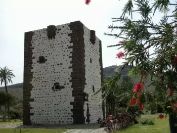
The first building to be erected, even before the island was totally conquered, was the house of the  Peraza family, located in the present terrain of El Pozo de la Aguada, the Church of the Asunción (Assumption), whichat the time was only a small hermitage, and the Torre del Conde ( The Tower of the Count), situated in the centre of the bay.
This latter construction is the only one of the three that still conserves its original aspect.
The island capital developed around two points, one around the house of the Peraza family and the other around the Churh of the Assumption, places that determined the future Calle Real (Royal Street), itself the beginning of the Camino Real, the main avenue of the island.
 The first map of San Sebastián dates from a century and a half after its founding, and the same document presents an aspect of the city quite similar to the one it would maintain for the next three hundreds years. In this rapid development the activity of the port and the business that grew up around it –taverns, inns, workshops- played an important role.
Columbus’ stop on La Gomera was welcomed by the lords of the island, who gave him all the help he needed and allowed the provisioning of his ships with food, water and wood. From here  Columbus leaves on his adventure of the unknown on the 6th of September,1492. After his first voyage, he stopped again on the island on the 5th of October 1493, and finally on the 30th of May, 1498, since on his final voyage he did not anchor in the bay of San Sebastián.
The town population in 1558-1590 was of 625 inhabitants and some 125 houses. The urban centre was formed by four blocks, apart from a few buildings and a group of houses lined up next to the mountain. This disposition scarcely changed until the beginning of last century.
The 18th century began with a slow but steady recuperation, so that by the beginning of the following century the census1802 counted about 1.800 inhabitants in the town.
Throughout the 19th century the growth of the city surpassed the “boundary” of the Hermitage of San Sebastián, reaching up to the plains of El Tanquito.
The present economy of the district is derived in good measure from its function as capital and port for the island, with the consequent development of the Public Administration and of publics services, especially of transports, commerce and tourism. The construction sector also has a certain importance, and to a much lesser degree, the agriculture located in the “oasis” of the ravine.
Senderos:
 Lugares de interés cultural y paisajístico del municipio :
- la Torre del Conde,
- el museo Casa de Colón,
- el Pozo de La Aguada,
- la iglesia de La Asunción,
- el Parque Natural de Majona,
- los monumentos naturales de Los Roques
- el Barranco del Cabrito,
- la Reserva Especial de Puntallana...