Hikes of
La Gomera


Treks La Gomera
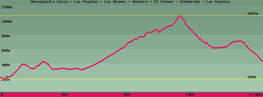
Hermigua/La Cerca - Las Poyatas - Los Álamos - Montoro - El Palmar - Enchereda - Las Casetas

Data sheet of the trail/hiking path 

1->2 - () Very good shape
 ->
->
 0,48 km
  34 m
34 m  27m
27m
2->3 - () Very good shape
1,80 km 189 m 84m
3->4 - () Regular shape
1,27 km 119 m 119m
4->5 - () Dirt road
1,82 km 35 m 36m
5->6 - () Dirt road
0,21 km 0 m 15m
Continue towards El Palmar. Further on the track splits on the right towards San Sébastien and on the left towards El Palmar.
6->7 - () Dirt road
0,97 km 87 m 0m
7->8 - (GR 132) Dirt road
2,70 km 370 m 36m
8->9 - () Good shape
4,97 km 398 m 520m
9->10 - (GR 132) Dirt road
0,88 km 20 m 3m
10->11 - (GR 132) Very good shape
0,97 km 86 m 10m
11->12 - () Very good shape
1,58 km 1 m 266m
Descend towards Las Casetas and the main road GM1. Arrived at Las Casetas, after crossing the road, the path continues towards El Atajo and San Sebastian.
Feedback(0) 
Fotos de la ruta
Recommendation for hiking:
Consult previously the state of the hiking paths with the Cabildo