Hikes of
La Gomera


Treks La Gomera
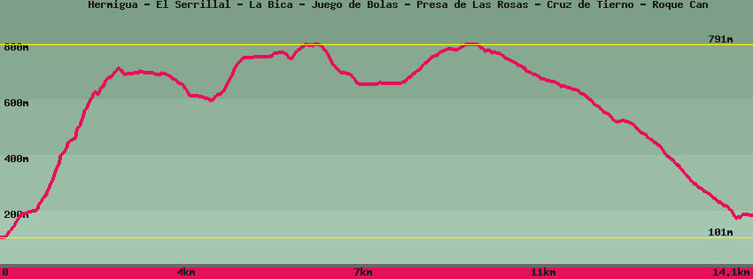
Hermigua - El Serrillal - La Bica - Juego de Bolas - Presa de Las Rosas - Cruz de Tierno - Roque Can

Data sheet of the trail/hiking path 

1->2 - () Very good shape
 ->
->
 0,87 km
  136 m
136 m  1m
1m
Follow a few ten meters to climb the stairs on the right before cafe terraces. Follow the stairs to the paved road. Turn left for a hundred meters up to a new staircase which leads to the upper road. On the left a few meters away is Le Serrillal and the start of the path.
2->3 - () Very good shape
1,78 km 477 m 29m
The path borders the houses then passes through the terraces before attacking the cliff. Depending on the time of year the trail can present some difficulties, but the view is magnificent along the climb and at the top of the cliff. A small descent takes us to the track that leads to the antennas on the right at the top of the cliff and on the left goes up the barranco de la Vica.
3->4 - () Dirt road
0,24 km 8 m 0m
Go up the track to the next bend from where the path begins that descends to the bottom of the La Palmita.
4->5 - () Very good shape
1,34 km 19 m 118m
Let's go down the path in the middle of the forest. Arrived at the houses, the descent is done by a cemented staircase until the track which we follow on the line until a bridge. On the left a track goes up in the direction of some houses and the visitors' center of Juego de Bolas. Straight ahead the track heads towards Agulo or the Mirador d'Abrante.
5->6 - () Very good shape
0,65 km 153 m 0m
Go up towards the houses and then follow the path to the Visitors' Center where there is a lot of information on the Garajonay National Park. On the right Agulo or the viewpoint of Abrante. On the left Las Rosas and Vallehermoso.
6->7 - (GR 132) Very good shape
2,24 km 74 m 170m
Follow the road and take the right one at the fork. A few meters before the bend leave the road and take the marked path towards Las Rosas/Vallehermoso. Go back down on the dam, pass on the dike.
7->8 - () Very good shape
2,22 km 149 m 36m
Go up the road bordering the lake and turn right before the end of the road to go up and around the overhanging house. The track turns into a path, then on the ridge again into a tarmac track until the junction. Continuing the road for a hundred meters finds the restaurant of Cruz de Tierno. On the right begins a dirt track towards Vallehermoso.
8->9 - () Very good shape
4,82 km 25 m 608m
Take the track then the path that will follow the ridge. This passes at the foot of Roque Cano, an old volcanic chimney, before descending to the village of Vallehermoso. The Place Centrale houses the Town Hall, the Pension Amaya, a few bars/restaurants and shops.
Feedback(0) 
Fotos de la ruta
Recommendation for hiking:
Consult previously the state of the hiking paths with the Cabildo