Hikes of
La Gomera


Treks La Gomera
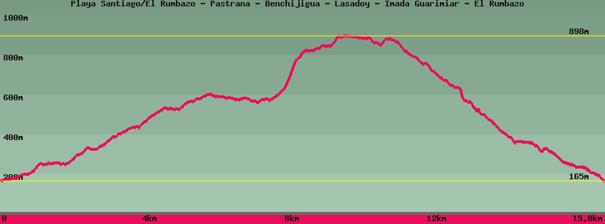
Playa Santiago/El Rumbazo - Pastrana - Benchijigua - Lasadoy - Imada Guarimiar - El Rumbazo

Data sheet of the trail/hiking path 

1->2 - () Very good shape
 ->
->
 0,67 km
  33 m
33 m  0m
0m
2->3 - () Very good shape
2,32 km 248 m 47m
3->4 - () Very good shape
2,40 km 229 m 26m
4->5 - () Very good shape
1,29 km 27 m 56m
5->6 - () Very good shape
1,10 km 207 m 6m
6->7 - () Very good shape
0,64 km 76 m 2m
Let's continue towards the pass which is just above above the abandoned village of Lasadoy. Let's leave the path on our left which leads to terraces. Further on, a path climbs to the right towards Tajaque on the backbone of the island, to the left it follows in the direction of Imada.
7->8 - () Very good shape
1,79 km 111 m 75m
Let's follow in the direction of Imada. Soon we see the small village of Imada which we reach by a cement path, paved and bordered by a balustrade, up to the road and the bar of Arcilla.
8->9 - () Very good shape
2,40 km 9 m 397m
Let's go down the paved road from the Arcilla bar, to the basketball-handball court on the left and down the stairs before the court. Then cross the road to go down the stairs which pass above the houses. Arrived on a path that descends from the road, turn left. The trail is marked and passes through a narrow gorge before crossing an abandoned irrigation canal.
9->10 - () Very good shape
0,87 km 4 m 144m
Leave the canal following the path that descends towards the hamlet of Guarimiar. Just before reaching the houses, from the bed of the river, the path goes up towards them to continue towards the Rumbazo and Playa Santiago. Following the bed of the river you reach the end of the paved road.
10->11 - () Very good shape
0,41 km 19 m 18m
11->12 - () Very good shape
0,99 km 31 m 141m
12->13 - () Very good shape
0,86 km 25 m 109m
Feedback(0) 
Fotos de la ruta
Recommendation for hiking:
Consult previously the state of the hiking paths with the Cabildo