Hikes of
La Gomera


Treks La Gomera
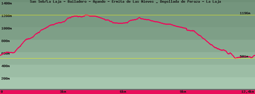
San Seb/La Laja - Bailadero - Agando - Ermita de Las Nieves _ Degollada de Peraza - La Laja

Data sheet of the trail/hiking path 

1->2 - () Regular shape
 ->
->
 2,55 km
  506 m
506 m  17m
17m
At the end of the La Laja road, climb the cement ramp then follow the dirt track to the dam. Follow the path for 50m, then go up to the right towards a remnant of volcanic dyke (wall) which you bypass on the left. The path is marked by 2 rows of pebbles, however, on the rocky parts they may be absent: pay close attention also to the bends, a continuation of the path may appear which is false, when it has followed a pronounced curve. This part of the hike arrives at the Mirador del Bailadero. A short round trip allows you to enjoy the view of the entire Hermigua valley. If it is the time, the "Tajinaste azul", Gomero endemism, will be in bloom. Climb the stairs to reach the road.
2->3 - () Very good shape
0,57 km 53 m 0m
Longer la road for 10m then enter the forest following the direction of Reventón Oscuro/Los Roques. The path leads to the Reventón Oscuro car park where the paved track from the village of Cedro joins the CV14 cross road.
3->4 - () Very good shape
1,61 km 136 m 58m
From the upper corner of the car park, climb the few steps. The path goes deep into the forest towards Los Roques and the dorsal road where it joins the GR131 which crosses the road (GM2) coming from Alto de Garajonay and then continues towards San Sébastien.
4->5 - (GR 131) Very good shape
0,74 km 5 m 100m
Follow in the direction of San Sébastien (GR131), The path enters the forest again to make a loop intended mainly for those who only do this one. The alternative is to follow the side of the road for 50m and find the path on the left a little further down. Follow the GR131 through the viewpoints. One of these, overlooking the whole of Roques, requires recrossing the road below the 1st watchtower and walking some 50m more before returning. Descend to the rock of Agando and the structure in tribute to the dead caused by the fire of 1984 in this place. On the right, below, a path leads to Benchijigua.
5->6 - (GR 131) Very good shape
0,37 km 2 m 10m
Cross the road and follow until the junction of the path which goes up on the left from La Laja. Straight ahead is San Sebastian and the Hermitage of Las Nieves.
6->7 - (GR 131) Very good shape
1,23 km 93 m 33m
Walk along the road a little and leave it in the direction of the Hermitage of Las Nieves and San Sebastián. Cross the forest of giant heathers before arriving at the Hermitage. From the square, the panorama over the entire south of the island and Playa Santiago in the background is absolutely irresistible. The place is equipped with tables, benches and shelters. Since the first inhabitants of the island, the place has always had a great cultural and religious importance, witnesses are the old sacrifice area and the chapel.
7->8 - (GR 131) Very good shape
2,06 km 7 m 186m
Down the tarmac road for 300m to the bend where the path resumes on the left (GR131/San Sébastien). down to the road and the Degollada de Peraza viewpoint.
8->9 - (GR 131) Very good shape
0,30 km 4 m 55m
Down some 200m by the path below the point of view in direction La Laja/San Sebastián, GR131.
9->10 - () Good shape
1,96 km 20 m 412m
Leaving the GR131 descend towards La Laja via a well-paved but steep path. Arrived at the hamlet, on the right the path descends towards the bottom of the valley then the paved road opposite, on the left it joins the upper part of the hamlet and Los Roques (Agando).
10->11 - () Very good shape
0,50 km 46 m 18m
Go up to the top of the village ( agando). The path, parallel to the road but on the other side of the valley is practically flat until the crossroads where on the one hand, on the left it goes up towards Agando, straight ahead, flat, it joins the highest houses of the village.
11->12 - () Very good shape
0,47 km 43 m 26m
Go up to the top of La Laja and follow until the last houses then find the end of the road which goes down again towards San Sébastien.
Feedback(0) 
Fotos de la ruta
Recommendation for hiking:
Consult previously the state of the hiking paths with the Cabildo